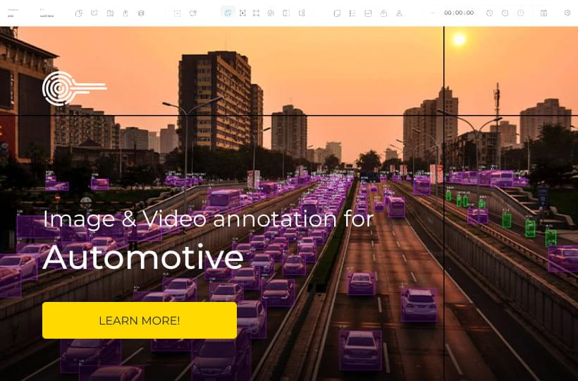
Mastering LiDAR Annotation for Autonomous Systems
Labeled data is the basis for training AI models, which is necessary for climate research and resource management. Methods for annotating LiDAR data are essential in autonomous systems. Automated tools process images faster when trained on accurately annotated data.
LiDAR annotation enables sophisticated perception capabilities in autonomous vehicles and drones. It provides richly labeled data for object detection, segmentation, and navigation.
What You Need to Know
- LiDAR annotation methods improve the perception capabilities of autonomous vehicles and drones.
- Accurately labeled data is essential for machine learning and navigation models.
- Proper training of automated tools increases the efficiency of data processing.
- Guidelines for annotating LiDAR data are necessary for safety and accuracy in autonomous systems.

What is LiDAR?
LiDAR, Light Detection, and Ranging uses laser light to measure distance. It sends laser pulses and measures their return after hitting an object. This method creates 3D maps of its surroundings. The accuracy is measured in centimeters, suitable for autonomous driving and environmental modeling.
How LiDAR Works
LiDAR sensors consist of a laser, a scanner, and a GPS. The laser emits pulses of light that bounce off objects and return to the sensor. The time it takes for them to return helps calculate distance and create a 3D image, even in rain or fog.
LiDAR Applications
It is used in the automotive industry for real-time navigation, route planning, and obstacle avoidance. Algorithms like PointNet and PointPillars use this data to locate and classify objects and improve the safety of self-driving cars.
LiDAR is used in other areas:
- Environmental monitoring with tracking of vegetation and terrain changes.
- Aerial mapping to create accurate topographic maps.
- Drones for cartography and terrain monitoring.
- Archaeology to detect objects underground.
- Meteorology to study the atmosphere and clouds.
LiDAR Annotation
It allows systems to recognize objects and determine their size, shape, and location in three-dimensional space. This is necessary for autonomous systems to operate effectively, as well as route planning and obstacle avoidance.
Role in Machine Learning
LiDAR annotation is needed to train machine learning models for autonomous vehicles. It provides information about the location of objects in the environment.
Annotated LiDAR information is used for data processing and path planning, creating safe trajectories for autonomous navigation. High-quality data annotation is key to algorithm accuracy and autonomous vehicle safety. Companies that invest in accurate annotation gain an advantage and build consumer trust. Read more
Impact on Autonomous Systems
Data processing and path planning are annotated LiDAR information. It creates trajectories for autonomous navigation. High-quality data annotation is the algorithm's accuracy and the autonomous vehicle's safety. Companies that invest in accurate annotations have an advantage and consumer trust.
Point Clouds
LiDAR data elements are essential for optimizing their annotation. LiDAR scanners collect large datasets, called LiDAR point clouds, that detail the studied environment. They contain billions of data points, each with unique coordinates and attributes. LiDAR point clouds are used in various applications, from autonomous vehicles to geographic mapping. They create a 3D view for digital elevation models (DEMs), digital surface models (DSMs), and classified point clouds.
Data formats
Formats such as LAS, LAZ, and PLY store, process, and analyze data. YellowScan can manage raw LiDAR data with special software and has tools for point cloud filtering, classification, and export.
Sensor Specifications and Types
Sensor types vary in range, accuracy, pulse rate, and field of view. These characteristics determine the accuracy of data. Different types of sensors serve everything from small drones to self-driving cars.
Key Features:
- Range determines the distance to capture data points.
- Accuracy of point cloud measurements.
- Pulse Rate affects the density and saturation of data.
- The field of view affects the width of the area covered.
Knowing this will help you match LiDAR sensors to project requirements.
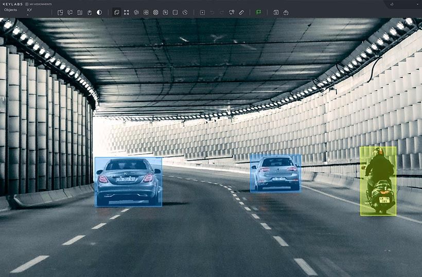
LiDAR annotation tools
These tools include point cloud, 3D bounding box, and semantic segmentation tools.
- A point cloud is a discrete set of data points in space.
- A 3D bounding box wraps around an object, creating a box with coordinates to determine the object's size, shape, and position.
- Semantic segmentation tools recognize and label objects in images or 3D scans.
There are different annotation methods used to enhance LiDAR data, each serving a specific purpose. Here you can compare and understand the benefits of each method.
These tools make annotation accurate and valuable in autonomous driving, medicine, aviation and drones, security, and surveillance.
Quality Control
Quality control of LiDAR annotations is important to ensure accurate data. It helps to solve problems with dataset complexity and incorrect labels, improving the performance of autonomous systems.
Denoising strategies in LiDAR data help to clean the data of unnecessary information. The main filtering methods are:
- The median filter removes random noise.
- Outlier detection finds and eliminates anomalous points.
- Gaussian filter smoothes the data with minimal distortion.
These methods ensure the accuracy of the data for annotation.
Data Normalization
LiDAR data normalization methods are used to standardize measurements. This can be achieved by:
- Min-Max normalization, which scales the data to a range of 0 to 1
- Z-score normalization centers the data around zero with unit variance.
- Log transformation reduces skewness by converting the data to a logarithmic scale.
Combining these methods increases the quality of datasets and improves machine learning models.
Multi-Sensor Fusion
Multi-sensor fusion combines LiDAR data with camera and radar data to provide a detailed overview of the environment. The process involves synchronizing the data, calibrating the sensors, and merging the data into a single set.
LiDAR data integration is essential for navigating complex and dynamic environments. This allows autonomous systems to operate effectively in complex and changing real-world conditions.
Quality metrics
These are essential for evaluating the effectiveness of LiDAR annotation. Metrics include:
- Annotation accuracy is the percentage of data points that are correctly annotated.
- Consistency of annotations across datasets.
- Completeness ensures that critical data points are not missed during annotation.
Collaboration platforms increase consistency by making it easier for teams to create annotations and fix errors.
Validation checks
They detect and correct errors and inconsistencies. Automated workflows and active learning algorithms increase annotation accuracy and reduce costs. Continuous monitoring reduces annotation errors.
Improvement strategies through performance analysis lead to accurate annotation. LiDAR annotation checks ensure high-quality datasets for autonomous system operation.
Established quality standards, rigorous validation, and robust quality assurance processes for LiDAR data are important for annotation. They provide a foundation for developing robust AI models for autonomous vehicles, drones, and other systems.
Trends Impacting LiDAR Technologies
The data annotation market is expected to grow to $8.22 billion by 2028, driven by demand for automated labeling in digital commerce, finance, and agriculture. Modern LiDAR scanners create 3D maps by sending up to 100,000 pulses per second, improving the navigation of self-driving cars and drones.
AI in LiDAR Annotation
AI transforms LiDAR annotation, rapidly processes data, and improves accuracy. Automating data labeling reduces human error. AI-driven LiDAR annotation reduces errors and improves efficiency in data labeling.
Automatic annotation is essential for processing large amounts of data. By 2025, unstructured data will grow to 175ZB, requiring new approaches to labeling it. The improvement of LiDAR depends on the development of AI and data processing. Combining automatic annotation and LiDAR will provide accurate and scalable processing, impacting urban planning and advanced driver assistance systems (ADAS).
Case Studies in LiDAR Annotation
Experience with LiDAR reveals its capabilities. We will look at successful examples of autonomous vehicles and drones.
Autonomous vehicle applications
Google's Waymo is a good example of an autonomous vehicle (LiDAR) application. It uses new LiDAR systems to map the environment in detail. The system sends up to 500,000 pulses per second, which allows it to identify different objects.
Object identification and real-time data processing are required for autonomous LiDAR applications. High-quality data annotation is the key to reliable navigation. The Velodyne HDL-64E is accurate thanks to 64 lasers. This data is then annotated to create reliable object detection models.
Drones
LiDAR improves drone performance by providing accurate aerial photography and 3D mapping. For example, AeroVironment uses this technology to create detailed terrain maps — from cities to fields. The quality of such maps depends on the accuracy of data annotation, which is vital for construction, environmental monitoring, and urban planning. To improve data reliability, companies combine LiDAR with cameras and other sensors.
Enhancing LiDAR Annotation Skills
Mastering LiDAR annotation is essential for developing autonomous systems such as drones and self-driving cars. High-quality data improves AI algorithms, increasing their accuracy and adaptability. Since working with 3D point clouds is complex, learning and collaborating with the community is essential.
Use quality tools and proven solutions to learn new data annotation and processing techniques. Keylabs offers advanced data annotation tools that help improve the accuracy of your AI models. Our platform works with multiple annotation formats, integrates with ML processes, and ensures data security.
FAQ
How does LiDAR technology work?
LiDAR technology emits laser pulses and measures the time for light to bounce back. This data creates precise, three-dimensional models of the environment. It uses laser emitters, scanners, and sensors to capture detailed spatial information.
What is the importance of LiDAR annotation in machine learning?
LiDAR annotation is key in machine learning, providing labeled data for algorithms. High-quality annotations boost the reliability and safety of autonomous systems. They improve object detection and scene understanding.
What are point clouds in LiDAR data?
Point clouds are data points in space that represent the three-dimensional shape of objects captured by LiDAR sensors. They are essential for creating detailed 3D models in applications like autonomous navigation and geographical mapping.
Why is quality control essential in LiDAR annotation?
Quality control ensures data accuracy and consistency, affecting machine learning model performance. Clear quality metrics and regular validation checks are necessary for reliable autonomous systems.
What preprocessing techniques are essential for LiDAR data?
Essential preprocessing techniques include noise reduction and data normalization. Noise reduction filters out irrelevant data points, while normalization standardizes measurement scales, making data consistent and more straightforward to annotate.
How does integrating LiDAR with other data sources enhance performance?
Integrating LiDAR with other sensor inputs, such as imagery and radar, improves performance by combining sensors.
What are the future trends in LiDAR technology?
Future trends include the use of artificial intelligence for annotation, improved sensor integration, and advances in sensor technology. This will improve the accuracy of data processing and expand the application of LiDAR in various industries.