Satellite Imagery Labeling: Extracting Information from Geospatial Data
More than 1,700 satellites orbit the Earth, capturing terabytes of visual information every day. This volume of orbital data has transformed the way we explore our planet.
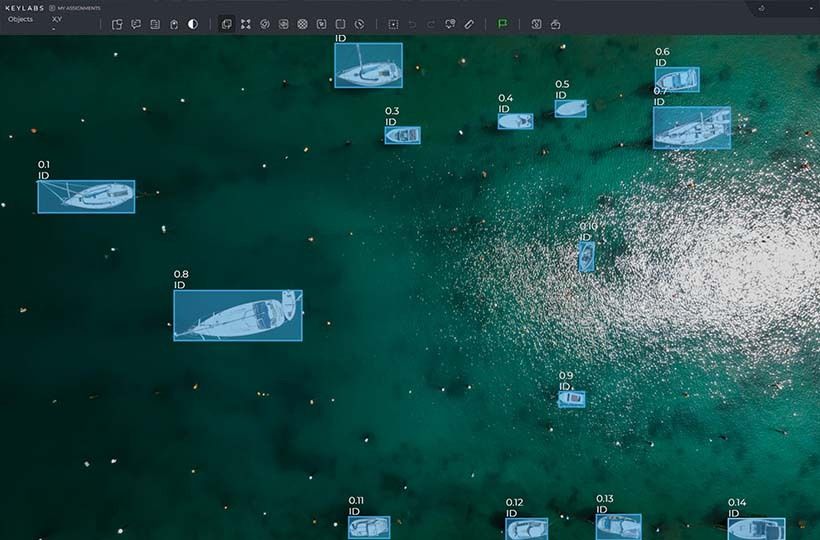
Tools that were developed during the Cold War are now driving commercial innovation. Today, machine learning models process high-resolution visual images with pixel-precise accuracy. They detect everything from illegal logging to parking lot occupancy.
Cities use annotated visual images to plan emergency routes during floods. Energy companies monitor pipeline corrosion. All of this requires precise annotation to turn abstract shapes into actionable intelligence.
Quick Take
- Military-grade surveillance technologies are powering global industries.
- Modern systems analyze changes in the Earth's surface in real time.
- Accurate annotation turns pixels into predictive data.
- Urban planning and disaster response rely on annotated visuals.

The Evolution of Satellite Imagery
Early systems were designed to gather strategic military intelligence, capturing details about the infrastructure and terrain of rival nations. Systems from the 1960s could distinguish objects the size of trucks, but access was limited for decades. A 1984 policy allowed commercial use for agriculture and urban planning.
The Earth Remote Sensing Policy Act of 1992 standardized data sharing. Sensor resolution improved between 2000 and 2010, allowing them to distinguish details smaller than 50 centimeters across any area. Today's platforms map 98% of the Earth's inhabited surface every week, helping monitor deforestation and the health of crops worldwide.
Weather agencies now predict storms with high accuracy, and environmentalists track the loss of Arctic ice.
Remote Sensing and Image Processing Basics
Light behaves differently at different wavelengths when it hits the Earth's surface. Visible light (400-700 nm) reveals colors but ignores important details. Near-infrared (700-1300 nm) reveals plant health through chlorophyll reflection. Mid-infrared (1300-3000 nm) reveals moisture levels in soil and vegetation.
Atmospheric conditions, such as cloud cover or pollution, alter the energy absorption rate. Snow reflects most of the visible light and absorbs most of the mid-infrared wavelengths, making multispectral analysis essential for accurate interpretation.
Whiskbroom vs. Pushbroom Scanners
Modern geospatial technology uses two types of sensors.
To effectively use geospatial technology, it is necessary to understand the physics of energy and sensor technology.
Geospatial and satellite imagery applications
Time series analysis allows for the precise detection of environmental changes. Researchers track glacier melt through Landsat archives dating back to 1972. As a result, it was determined that some glacier fields lost between 2% and 39% of their mass from 2000 to 2023.
When hurricanes approach, GIS platforms predict flooding areas using terrain models and rainfall forecasts. A 2024 study by San Diego State University (SDSU) showed that thermal infrared aerial photography allows for real-time monitoring of fire intensity. This helps rescuers make quick decisions about evacuation and resource allocation.
Combining soil moisture maps with crop yield forecasts in agriculture helps optimize irrigation. This helps save resources while maintaining the quality of production.
Key Aspects of Spectral and Spatial Resolution
Resolution determines whether we see continents or cracks. Sensors capture 143 spectral bands across the electromagnetic spectrum, but only a small fraction are used effectively. The right combination separates actionable insights from noise.
Importance of spectral bands
The wavelength determines what it can detect. Near-infrared detects plant stress weeks before color changes, while short-wave infrared detects soil moisture levels. Agricultural services use this data to determine irrigation needs, predict crop yields early, and detect pest infestations.
Modern mapping tools
Modern mapping's main functions are automatic feature recognition, time series analysis, digital terrain modeling, and interactive visualization of spatial data.
Cloud-based platforms process large volumes of satellite imagery and combine them with geospatial databases. This allows users to create high-resolution maps without the need for powerful hardware. Many tools support machine learning for land cover classification, crop assessment, or deforestation detection. Browser-based visualization systems have features for collaborative data analysis and publishing dynamic maps with real-time access.
Augmented reality and mobile mapping allow spatial data to be collected in the field while sensor platforms and unmanned aerial vehicles update data accurately. Integrating analytics with artificial intelligence makes mapping systems an analytical tool for real-time decision-making.
Interpreting and analyzing remote sensing data
Comparing time series reveals changes in the environment that are invisible to ordinary observation. Landsat archives track the rate of urban expansion, and MODIS provides updates for monitoring wildfires. These types of temporal analysis help cities predict flood zones.
Three steps to monitoring:
- Establish a baseline using historical composite data.
- Detect anomalies based on thresholds.
- Human verification of automatically generated alerts.
Image classification methods
Supervised methods are machine learning approaches in which an algorithm is trained on pre-annotated data. In this data, each input has a corresponding correct output. Supervised methods are suitable for identifying crop types.
Unsupervised clustering is an unsupervised learning method in which an algorithm automatically groups similar objects into clusters without predefined labels. The main goal is to discover hidden patterns or similarities between data when it is not known what classes or categories exist. This method reveals hidden patterns in uncharted regions. This helps energy companies find potential drilling sites.
Essential Terms: DEM, DN, GSD, and More
These concepts allow you to maintain quality and avoid agriculture and emergency management errors.
Future trends and innovations in satellite imagery
The development of optical, infrared, and radar sensing technologies contributes to the emergence of systems that record changes on the Earth with an accuracy of a few centimeters. Artificial intelligence algorithms and intense learning are also being implemented to automatically recognize objects and landscape changes.
The development of satellite constellations that constantly update information. This monitors emergencies such as forest fires, floods, or illegal logging. The direction of mini-satellites (CubeSats) is actively developing, which are cheap to launch and allow organizations of various levels to receive up-to-date images.
FAQ
Which industries benefit most from geospatial data?
Agriculture, urban planning, environmental monitoring, and disaster response.
How does spectral resolution affect image analysis?
Spectral resolution determines how accurately sensors capture wavelength ranges. Higher resolution distinguishes between materials such as minerals or vegetation, which is important for research and resource management.
Why is temporal resolution important for monitoring projects?
Reviews allow you to track changes such as the progression of floods or deforestation.
How is artificial intelligence changing the annotation of satellite imagery?
Machine learning automates feature detection, such as identifying roads or crop types.
What do terms like DEM and GSD mean in practice?
A digital elevation model (DEM) represents the terrain, which affects flood modeling. The ground sampling distance (GSD) determines the pixel size.