


Aerial
Sky-high precision for aerial AI with Keylabs' annotation expertise.
In today's world, data is the new gold. And when it comes to the aerial industry, data annotation tools are becoming increasingly important. With the rise of technology, aerial imagery and satellite data are being used more and more in various fields such as energy sector, property monitoring, road traffic reporting, disaster management and geospatial surveys. However, without proper annotation, this data is just a collection of pixels and numbers.
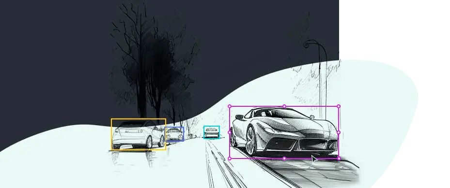
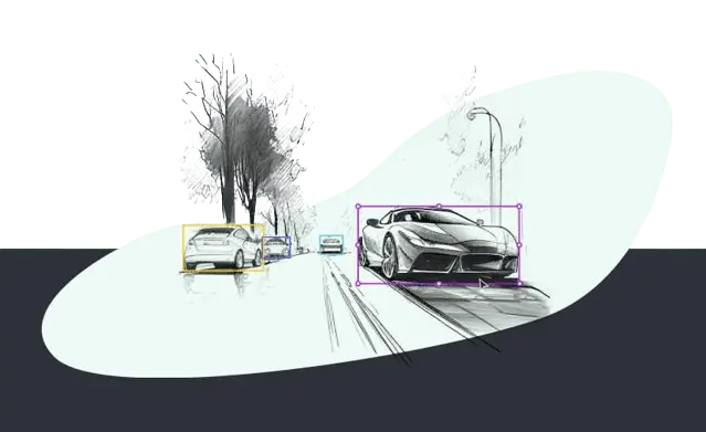
Data annotation is a crucial step in the ongoing development of aerial industry applications. Keylabs offers an advanced toolset for annotating aerial images and videos with various techniques available, including point, bounding box, rotated bounding box, polygon and 3D Point Cloud annotation. These tools ensure accurate marking up of training datasets for subsequent data analysis.

Data annotation tools for aerial systems
Enhanced perception
Perhaps one of the most valuable aspects of data annotation in the aerial industry is its role in empowering advanced perception for aerial systems. When aerial imagery is annotated, machine learning models can effectively understand and interpret the data, fostering superior object recognition and decision-making abilities. This enhanced perception capability is essential in diverse applications such as terrain analysis, wildlife monitoring and disaster management, to name a few.
Driving precision in aerial navigation
Data annotation is also instrumental in refining the precision of aerial navigation. Annotated data plays a pivotal role in improving the accuracy of geolocation predictions, thereby facilitating optimal navigation routes and improving flight efficiency. From commercial airline operations to unmanned aerial vehicle (UAV) deployments, the impact of data annotation on aerial navigation is profound and transformative.

Facilitating aerial infrastructure inspection
The task of inspecting and maintaining expansive infrastructures, such as power lines and pipelines, is a mammoth task. Thanks to the power of data annotation, aerial systems can now perform infrastructure inspections with an unprecedented level of precision and efficiency. Annotated data equips these systems to identify potential faults and anomalies swiftly, enabling proactive maintenance and reducing operational downtime significantly.

Climate studies and agriculture
Climate studies and agricultural planning heavily rely on accurate data gathered from aerial platforms. When this raw data is annotated, it provides a treasure trove of valuable insights. The ability to discern patterns in weather data or identify crop diseases at an early stage are just a few examples of how data annotation is revolutionizing these sectors.
Defense applications
In the realm of defense, the role of data annotation is crucial in equipping aerial systems with the ability to interpret and respond to dynamic situations. Whether it's identifying potential threats, analyzing strategic locations, or aiding in search and rescue missions, the value of data annotation in defense applications is indispensable.
Data annotation techniques for the aerial industry
Ground truth data annotation is important for aerial applications to ensure that the collected data is accurate and can be used effectively. To achieve pixel-accurate and polygon annotations in aerial imagery, various kinds of annotation techniques are being used. These methods help in identifying objects in the images, such as buildings, roads and trees, by marking their specific boundaries.
One common technique used for aerial imagery labeling is bounding box annotation. This method involves drawing a rectangle around an object to identify its location accurately. Another popular technique is semantic segmentation, which includes labeling each pixel in an image with a specific object or class label. For instance, labeling vegetation with green labels or water bodies with blue labels.
In addition to these techniques, point annotation is becoming more popular for annotating key points in aerial videos. By identifying key points like from where smoke has started at a forest fire scene which helps organizations to respond swiftly to the situation locally and making timely decisions on how aid can be provided from other locations globally.
Using these data annotation techniques ensures that the data collected from aerial images can be utilized efficiently by various industries such as agriculture-based industries or city planning departments looking for insights into traffic patterns during different hours of the day. Applying proper annotations allows machine learning models to understand what they are detecting accurately, leading them to further process an enormous amount of information that would have been beyond any human capability otherwise.
Key features
There are several key features that a robust data annotation tool for aerial applications should possess:


Versatility
The tool should be capable of handling different types of data, including 2D and 3D images, videos and point clouds generated by LiDAR sensors.


Precision
High-quality annotations are crucial for the accuracy of AI models in aerial management and disaster management. The tool should enable precise labeling of objects and features, minimizing the chances of misinterpretation.


Scalability
A data annotation tool should be scalable to handle large datasets efficiently, streamlining the annotation process and reducing the time required for model training.


Automation
AI-powered data annotation tools can leverage machine learning algorithms to automate parts of the annotation process, speeding up the workflow and increasing overall efficiency.


Collaboration
A good data annotation tool should facilitate collaboration among team members, enabling multiple annotators to work together on the same dataset. This ensures consistency in labeling and accelerates the annotation process.


Quality control
To ensure the highest level of accuracy, the tool should have built-in quality control features that allow for easy review and verification of annotated data. This helps maintain data integrity and improves the overall performance of the AI models being trained.


Customization
The annotation requirements may change or become more complex. A flexible data annotation tool should allow for customization to meet the unique needs of each project and adapt to new challenges in the industry.


Integration
The data annotation tool should be able to integrate seamlessly with various machine learning frameworks and platforms, making it easier for developers to use the annotated data for model training and evaluation.


Data Security
A data annotation tool must prioritize data security and privacy, ensuring that the information is protected at all stages of the annotation process.
Versatility
Precision
Scalability
Automation
Collaboration
Quality Control
Customization
Integration
Data Security
Use cases

Energy sector
Keylabs platform is engineered to handle all dataset formats, crucial for the diverse and complex data landscapes. With a focus on high-quality, accurate labeling, we facilitate the development of sustainable and efficient energy sector applications.
Satellite image annotation
A range of labeling tools tailored to meet the unique complexities of satellite data. Compatible with all data formats, our high-precision annotation ensures unparalleled accuracy for applications from environmental monitoring to global security.

Property monitoring
Compatible with all data formats, our high-precision annotation ensures top-tier accuracy, elevating your property monitoring applications to the next level.

Road traffic reporting
With compatibility across all data formats and a commitment to high-precision annotation, we provide unparalleled accuracy essential for real-time traffic insights and management.
Starter’s guide


Data security
Using the Keylabs annotation tools comes with a commitment to data safety. Keylabs employs a range of security measures to protect valuable and sensitive data. This includes comprehensive infrastructure security if you choose to access Keylabs through the cloud. Alternatively, Keylabs can be installed on premises, guaranteeing you total control over access. We will continue to emphasize data protections as a priority by utilizing a diverse array of security measures and industry best practices.
Top Features
Keylabs is created as a platform that incorporates state-of-the-art, performance oriented tools and processes.

ML assisted data annotation
ML assisted data annotation
Keylabs is a streamlined data labeling platform with AI-enhanced annotation.
Tailored for easy Integration with any client model and time & cost efficiency.
Keylabs’ advanced algorithms provide quick, accurate data prep for superior model training.

3D tool
3D tool
Keylabs is a super-fast tool, soaring through Lidar files at ultra speeds. It seamlessly handles all file formats, ensuring a consistent, efficient workflow regardless of file complexity.

High performance video annotation
High performance video annotation
With the Keylabs platform's technical and software capabilities, video annotation is highly accurate (precision of up to 99,9% depending on project needs) and fast. Thanks to the geolocation adaptation of servers, even big-sized videos are loaded and processed quickly.

Magic wand
Magic wand
Speeds up the annotation process by automatically detecting closed shapes of the same color or color gradient in a highly precise manner.

Object interpolation
Object interpolation
Object interpolation in the data annotation process is used to accelerate the annotation of objects across a sequence of frames in video annotation.
Annotators label the shape of an object in the first and the last keyframe of desired sequence and the object interpolation algorithm automatically generates the labels for the object in the intermediate frames.
It saves time and also ensures consistent labeling across frames.

A-Z order
A-Z order
Objects can be placed on different leveled layers, which allows operators to correctly detect and work with those objects and their boundaries.

Multilayer annotation
Multilayer annotation
Multilayer annotation is a complex yet valuable process in data annotation where different types of materials are layered onto a single item.
This allows the addition of multiple, diverse annotations to a single piece of data such as an image or video frame.
Each layer might provide a different dimension of information, enriching the dataset with multiple facets of detail.
This allows the addition of multiple, diverse annotations.

Object linking
Object linking
Object linking in the data annotation process is a valuable function that connects different instances of the same object across multiple frames or images.
For example, in video annotation, an object appearing in different frames is linked throughout the video, ensuring the continuity and consistency of the annotation.

Hierarchical atributes
Hierarchical atributes
The attribute is a type of tag that can be applied to a class or property to provide metadata about it.
Using attribute hierarchies, it is possible to define structures of metadata for each item in dataset.
It is achieved by using dependent attributes, which allows logical forming of metadata information for frame or object individually.

Workflow and task distribution
Workflow and task distribution
Workflow includes custom stages of one of 4 project stage types: annotation, verification, miscellanious and final.
Good workflow and task distribution ensure that the data annotation process is smooth, efficient and completed within the required timeframe.

Data management
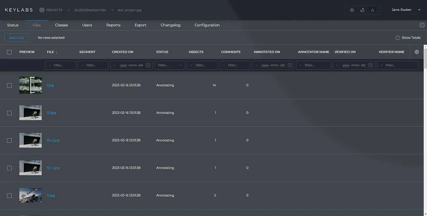
Data management
Data management in the context of the data annotation process is about strategically handling and organizing the data throughout its lifecycle.
Effective data management helps to uphold data integrity and ensure that the final annotated data is accurate, consistent and ready for use in AI and machine learning projects.

Attributes interpolation
Attributes interpolation
Attributes metadata can also be interpolatable (changed) between the frames. For instance, In a self-driving car video annotation, this can label a car as a "sedan" going "30 mph" in the first frame & automatically estimate its type & speed in subsequent frames until the next key frame. This eliminates the need for manual annotation in each intervening frame, saving time & effort.
Annotation types
Keylabs gives developers access to a full suite of annotation techniques:


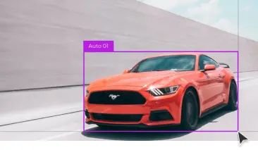
Bounding Box
A rectangular box defined by coordinates that encapsulates an object of interest within an image


Oriented bounding box
A rotated rectangle that tightly encloses an object, accommodating its orientation and shape more precisely than a standard bounding box


Polygon
A closed plane figure made up of several line segments that are joined together, used to define irregular shapes in an image


Points
The Point Annotation Tool places dots on images or videos, ideal for highlighting details like facial features, expressions and body postures


Lines & Multilines
A data annotation tool used to draw single or multiple interconnected lines on images, capturing linear features or paths


Skeleton
A thin version of a shape, representing its central structure and providing a simplified representation of its form, commonly used in understanding object morphology or structure


Instance Segmentation
The process of classifying and delineating each individual object instance in an image


Semantic Segmentation
The classification of each pixel in an image based on its semantic category, without distinguishing between individual object instances


Bitmask
A binary representation where each pixel value indicates whether it belongs to the object (1) or the background (0)


Cuboid
A 3D rectangular prism annotation, often used to represent objects in spatial dimensions


Mesh
A collection of vertices, edges and faces that define the shape of a 3D object in space, often used in 3D modeling and computer graphics


3D Point Cloud
A collection of data points in a three-dimensional coordinate system, representing the external surface of an object


Custom
A tailored data annotation tool designed to cater to specific annotation needs not covered by standard tools